Sunday, May 18, 2025

Glacier Bay: (a spot that wasn't really a "stop" and a National Park that didn't really feel like a "park")

National Park Service - Glacier Bay National Park - Icy Straits, Alaska
Copyright Andy Richards 2010 - All Rights Reserved

THE LAST "stop" on our itinerary before reaching our final port and debarkation, was Glacier Bay National Park. The park is actually over 3 million acres of rugged and essentially uninhabited mountains, glaciers, shorelines, and even rainforest. We didn't see any of that except on huge glacier making its way inexorably into the bay. Instead, we cruised into Glacer Bay, itself 65 miles long, primarily to observe The Margerie Glacier and maybe get lucky enough to see it "calving."

The Margerie Glacier - Glacier Bay National Park - Icy Straits, Alaska
Copyright Andy Richards 2010 - All Rights Reserved

THE BAY is open to only 2 cruise ships a day, and limited private boating (by permit only), in addition to the excursion boats operated by, or in contract with, the Park Service. As the ship enters the bay, it is boarded by Park Service Naturalists who accompany the boat during the time in the bay, as well as presenting to the passengers. We saw, in addition to the spectacular scenery, a fair amount of wildlife, including a couple black bears that were too far off to photography.

Floating Ice - Glacier Bay National Park - Icy Straits, Alaska
Copyright Andy Richards 2010

THE MARGERIE Glacier was the main event. Our ship cruised pretty close to the base of the glacier and then sat for a long time, turning once to allow all passengers a view. As we watched, we hoped for a significant calving event. Unfortunately we did not see a major "calving" event.

Floating Ice - Glacier Bay Natioal Park - Icy Straits, Alaska
Copyright Andy Richards 2010 - All Rights Reserved

AS I watched over the side, I was impressed by the huge chunks of ice floating in the clearly freezing-cold water, many of them displaying interesting and sometimes vivid colors.

Margerie Glacier - Glacier Bay National Park - Icy Straits, Alaska
Copyright Andy Richards 2010

THE BLUE color you see predominantly in the glaciers is caused by the dense icepack absorbing the colors of the "warm" spectrum (reds, oranges, yellows) and reflecting the cooler (blue) color spectrum.

The Margerie Glacier - Glacier Bay National Park - Icy Straits, Alaska
Copyright Andy Richards 2010 - All Rights Reserved

THE BLACK, mostly horizontal lines through the glaciers are made by deposits on top of the ice of minerals, smoke, dust and rock particles, recovered by snow and reformed ice. It all makes for a pretty photogenic, if pastel, palette.

Pilot Boat - Icy Straits, Alaska
Copyright Andy Richards 2010

SAILING OUT of Glacier Bay and on toward our final port of call, Whittier, we had calm seas, but very cold conditions. I couldn't help but think how brutal this environment can be and how incredibly cold it would be out there on a smaller craft. I thought the black and white rendering of this image got my primary thought - cold - across well.

Icy Straits Passage from Glacier Bay to Wittier, Alaska
Copyright Andy Richards 2010 - All Rights Reserved

WHITTIER IS a tiny Alaska town whose demographic is fascinating. Serving mainly the purpose of a small, sheltered seaport, the majority of Whittier's inhabitants work in the marine industry, mostly for the cruise port there which is operated by Princess (and is the point of beginning and end for the one-way inside passage cruises by Princess and Holland America cruise ships). Historically a portage point for the Chugach native people, it later was used by Russian and U.S. explorers, as well as serving as a launch point during the Klondike Gold Rush. During World War II, the United States built a military base (Camp Sullivan) nearby. Improvements, including a spur of the Alaska Railroad to Camp Sullivan, an oil terminal and a pipeline from Whitter to Anchorage. The army maintained its presence until 1960. In 1941, a tunnel was excavated through the mountain separating Whittier from other parts of Alaska, train travel (mostly industrial) was able to move between Whittier and Anchorage and other points. There were no roads in and out of Whittier. Previously mainly a military-industrial outpost and a port on the Alaska Marine Highway, Whittier was incorporated in 1968. It was not until 2000, however that the tunnel was converted into a "bi-modal" transportation route, for both passenger vehicles and train travel.
Begich Towers . . . continues today to be the primary housing in Whittier
IT WAS a very interesting trip from Whittier to Anchorage from where we would fly home the following day. The tunnel is regulated and is a basically one lane highway with train tracks in the middle of it. Obviously, only one mode of transport at a time can traverse the 2.5 mile stretch. And somebody has to be coordinating that! We took one of Princess' coaches, and fortunately met neither a vehicle nor a train coming into Whittier.

Sunrise from the aft deck of Diamond Princess in Whittier, Alaska
Copyright Andy Richards 2010

THE OTHER fascinating tidbit about Whittier is its population and housing situation. The population is less than 300. Almost all of them live in a single, high-rised condominium. As you can see from my photo of Whittier below, there is virtually no separate single family housing. In fact, aside from the two multi-occupancy buildings to the left and right of the image, there is essentially no other housing. Unique. Only two residential building were built in Whittier, the Buckner Building in 1953, and later, the Hodge Building in 1957. Both were multi-occupancy buildings. For reasons unknown to me, the Buckner Building was eventually abandoned. The Hodge Building was renamed to Begich Towers and continues today to be the primary housing in Whittier. On its ground floor, it houses the 3-person Whittier Police force, and a drugstore and grocery/convenience store. There is a tunnel from the building to the Whittier School, allowing students to go to and from school in any weather. It has become known as "the city under one roof." Sounds kind of like one of those "utopian" domes. As I said: Fascinating.

The city and port of Whittier, Alaska
Copyright Andy Richards 2010 - All Rights Reserved
ALTHOUGH WE took the Princess coach that morning back to our hotel in Anchorage, and we made a couple stops along the way, they were mostly anti-climactic and my lasting memory of the final day of that cruise will be that Whittier sunrise. It was a brand new adventure for us. Our first cruise. As I said at the beginning of this series of posts, I didn't know whether I would like it or not. It turns out we did. A lot. And even though it would be 2 more years before we cruised again, we began to look forward to the next one, and that has been the pattern ever since. Next up: The Caribbean.

Sunday, May 11, 2025

Skagway - A Fantasy Town?

"Downtown" Skagway, Alaska
Copyright Andy Richards 2010 - All Rights Reserved

OUR NEXT port of call was Skagway. As you might have gleaned from my posts so far, this part of Alaska along the inside passage, though it is the geographically smallest part of the state, holds some of Alaska's most archetypal towns, including the state capitol of Juneau, and Ketchikan, Haines, Sitka (which I wish we could have visited there), and of course, Skagway.

Inside Passage - Skagway, Alaska
Copyright Andy Richards 2010 - All Rights Reserved

TO THE east of the inside passage is the vast, wild, undeveloped and largely uninhabitated Yukon territory, virtually all in Canada. Alaska occupies part of the coastline which stretches around 1,000 miles from Ketchikan (just north of Vancouver, Canada) up to Skagway, where the passage opens up into the Gulf of Alaska. On that coastline, the land reaches east to the Yukon - a scant 100 miles at its widest point. By comparison, the Yukon stretches some 400 miles from the coast to its eastern boarder with the Northwest Territories, which are similarly rugged and uninhabited and continue yet another 1,200 miles to Hudson Bay. If you click into the photo of "The White Pass," below, using the train in the left middle portion of the image for scale, you get a feel for the vastness of the Yukon. Most of the Alaskan coastline is rugged, mountainous, and very sparsely populated once you clear the immediate coastal areas.

White Pass - Alaska/Yukon Territory
Copyright Andy Richards 2010 - All Rights Reserved

WITH THE possible exception of Juneau, which is the capitol city, the primary industries here are very limited. Today: primarily fishing and tourism (while Alaska is known for its oil and gas production, most of that is done nearly 1,000 miles north at the very northern tip of the state, what is known as "The North Slope," on the Arctic Ocean). There is some hunting, trapping and timber production also. A lot of entrepeneurs have build these industries into tourist attractions (like our Aleutian Ballad "Deadliest Catch" adventure), involving so-called "hands-on" experiences with dogsledding, panning for gold, and visits into parts of the Yukon.

Camp Skagway Arctic Brotherhood Hall
Skagway, Alaska
Copyright Andy Richards 2010 - All Rights Reserved

CRUISE SHIPS (years back it was steamship companies) have been bringing sightseers and visitors to Skagway since its beginning in the lat 1800's. But modern lines - like Princess - started their Alaskan cruising in the late 1960s. The port is one of the best ports on the Inside Passage, with room for 4 large cruise ships, in addition to the ferries from the "Alaska Marine Highway." This clearly makes tourism a long-time important industry for Skagway. Pre-Covid, in excess of 1 million cruise passengers visited Skagway annually (and predictions are that we will shortly again exceed that number). A recent hiccup (a serious rockslide in 2023 impaired the cruise terminals - my understanding is that has now been fixed), curtailing some cruise traffic.

Diamond Princess Docked in Skagway, Alaska
Copyright Andy Richards 2010 - All Rights Reserved

TUCKED ALL the way at the northern end of a fjord, the waters are relatively calm and protected, and the port is a very nice facility. As is not uncommon, our Diamond Princess docked during the night, and since our excursion did not occur until later that morning, I was - as is my custom - up early and on shore. I could see the harbor and the town from the upper cruise ship deck and I wanted to explore.

Skagway Harbor, Alaska
Copyright Andy Richards 2010 - All Rights Reserved

SKAGWAY HARBOR is not huge, but it is impressively capable of lodging a substantial number of boats of all description. I was interested - in addition to seagoing personal craft to see several exploration and research "ships" (maybe boats?).

Skagway Harbor, Skagway, Alaska
Copyright Andy Richards 2010 - All Rights Reserved

THE MORNING light was good and there were some nice, saturated colors as well as some great reflections on the water.

Skagway Harbor, Skagway, Alaska
Copyright Andy Richards 2010 - All Rights Reserved

MY RESEARCH of this part our trip told me that most of the "things to do" along Alaska's inside passage involved outdoor activity (fishing, hiking, visiting the glaciers, airplane and helicopter rides, etc). The only other things were to explore the quaint downtowns, visit exhibits showing local native culture (totem poles are big in this area) and history. Much of that has - sadly - become more "theatre" for the tourists and the economic opportunists (though I don't criticize locals for making a living any way they can).

White Pass & Yukon Railroad Depot
Skagway, Alaska
Copyright Andy Richards 2010 - All Rights Reserved

FOR OUR visit to Skagway, my research had disclosed a major attraction that is probably the main event for the Skagway stop: The Whitepass Railroad. There is a good historical story there. But before we get there: Skagway and my "fantasy" reference. As a whole, Alaska is very wild and sparsely populated. It is highly influenced by the "Alaska Native" population and their cultures and traditions. For many years, Alaska was known primarily for its fisheries - mainly salmon - and by the 1940's the salmon canneries had primarily moved up to Alaska from the U.S. Northwest. But there was one other huge "vocation" that Alaska, and particularly, The Yukon became wildly famous for: gold. The discovery of gold in the Klondike region of the Yukon, right at the U.S. - Canadian border, trigger perhaps the first North American "Gold Rush" in 1896. It is estimated that during the rush, some 100,000 "stampeders" tried to reach Dawson City and Klondike, the region where the find was. 10,000 - 20,000 of them took the overland route from Skagway and through The White Pass over the summit of the mountain range (after Sir Thomas White, who was the Candian Minister of the Interior at the time). It was brutal trip, and there were many deaths (from numerous causes). Skagway, a very small outpost founded by a former steamboat captain. His tiny homestead was inundated by gold seekers and Skagway grew overnight to a tent city, soon adding "infrastructure" which largely involved provisioning and services for he tens of thousands of "new" residents.

Locomotive Check - White Pass & Yukon Railroad
Skagway, Alaska
Copyright Andy Richards 2010 - All Rights Reserved

IN MAY, 1898, construction was begun on "The White Pass and Yukon Railroad," whose purpose was to get passengers up over the White Pass. It was completed in July 1900 (from Skagway to White Horse), perhaps the proverbial "day late and dollar short." By then, just 4 years after it had begun, the gold rush was over. Claims had been made and in many cases exhausted. There was no more gold, and the prospectors moved on to the next "find." Perhaps unfortunately, Skagway began to decline and at one point was no longer inhabited. A 1898 census showed Skagway's polulation was 10,000. By 1900, it had dropped to just over 3,000. Even so, Skagway endured, and became Alaska's first incorporated city (just a day before Juneau). The next years were filled with "fits and starts," with the railroad primarily being used to ship freight and goods up and minerals from mines operated by Faro. Responsible for 95% of the railroad's revenues, Faro eventually closed down. Though they attempted to build a tourism trade, the railroad eventually ceased operations for some years.

One of hundreds of spectacular views from the White Pass & Yukon Railway Train
Copyright Andy Richards 2010 - All Rights Reserved

IN 1976, Congress passed legislation creating a "Klondike Gold Rush National Historical Park." In June 1976 a temporary visitor center opened in the old depot. Still, for a number of reasons, it wasn't until 1988 that the railroad was reopened for a summer tourist operation with 3-hour round-trips to the summit. The former center city of Skagway, by the time we were there in 2010, was more of an amusement park attraction than a working city. The permanent resident population of Skagway today is just under 1,000. That swells to several thousand from temporary workers who come during the summer months to serve the tourists. There are numerous historical buildings there, some open for business, but clearly primarily serving the cruise passengers. It is pretty clear that without cruise ship passengers, there would no longer be a Skagway. You can read much more detail about the history of Skagway here.

White Pass & Yukon Railroad
Yukon Territory, Canada
Copyright Andy Richards 2010 - All Rights Reserved

AS YOU can see from the many photos here, we took the railroad trip. There are different iterations, but our involved riding the train up to Whitehorse, and then taking a bus back down, with a couple stops before being dropped of back by the cruise port. We stopped first at a "hokey," staged "camp" called Liarsville, where they performed a show with some folksy music. and let us "pan for gold." It was pretty fake and if lucky, you might get some gold flecks worth maybe pennies. I wouldn't recommend that you go out of your way to do this portion of your visit to Skagway.


THE SECOND stop (really our last) was more interesting, and involved a short, but personally narrated tour of the Red Onion Saloon. Wait. Tour of a Saloon? What could be that interesting about that? The Red Onion was not just a saloon, but was one of Alaska's most famous "Bordellos." Back during the gold rush. As I was doing some of my research, one commentator (unfortunately, I cannot remember the source to attribute it to - but it is sufficiently reminiscent of Mark Twain or Benjamin Franklin that I wouldn't be a bit surprised that what I read was not original either) said that during the Gold Rush there were two ways to get rich in Skagway: "work the goldmines or work the miners." Prostitution at the time was a booming vocation in Skagway. The Red Onion provided what they euphemistically called opportunities of "Negotiable Affection" in the upstairs area of the Saloon. What we saw was eye-opening. Rather than rooms, there were double-decker cubicles that were probably about 6 - 10 feet deep and not much higher or wider than that. They were referred to as "cribs," and our guide opined that it was the precursor of our current day use of the word "crib" to describe our own living quarters. Like all "legends," - maybe. 😉It's a good story anyway.

The Red Onion Saloon - Skagway, Alaska
Copyright Andy Richards 2010 - All Rights Reserved

FOLLOWING THE Red Onion tour, we found another saloon (or bar) that was just steps away from our boarding area for the Diamond Princess and in plain view. We had some time to kill before our all-aboard time, and it was a nice warm day (this was long before the days when we were routinely purchasing drink packages) and we decided to sit and have a drink or two. As time drew near we (perhaps unwittingly) started what might have become a "tradition" for us - last minute boarding. As we walked through the boarding gate, we heard one employee say to another, only two left (which meant we were almost the last on board). But on board we were, and it would be the last time our feet would be on terra firma until we disembarked from the ship a few days hence in Whittier.

Skagway, Alaska
Copyright Andy Richards 2010 - All Rights Reserved


Sunday, May 4, 2025

Another Year; Another Caribbean Cruise

Rainbow; Caribbean 2014
Copyright Andy Richards 2014 - All Rights Reserved
WE DEBUTED our Caribbean Cruising way back in 2012, aboard Princess' Ruby Princess, just two years after our first-ever cruise to Alaska. Living in northern Michigan in the center of SAD territory, a warm - weather cruise is a welcome respite. For the preceeding 35 years or so, we hunkered down during the cold season, working and saving, and reserving what time off we did have for trips to see family at Christmas and during the summer. Before that, my own family had a similar approach. For my dad, "spring break" was a good time to find a part-time job and save some money for college. Unlike many of my contemporaries, I had never taken a warm-weather, "spring break" (or any other time during the winter months) vacaton in my life.

we loved it. Who wouldn't?

PERHAPS NEEDLESS to say: we loved it. Who wouldn't? We left Saginaw, in February, covered in dirty, slushy, old snow; cold, grey and dreary. The next day, we boarded a cruise ship in Fort Lauderdale, and spent the next 10 days in the bright, warm sunshine. Though we didn't make it every year afterward, did a Caribbean Cruise several more times after that.

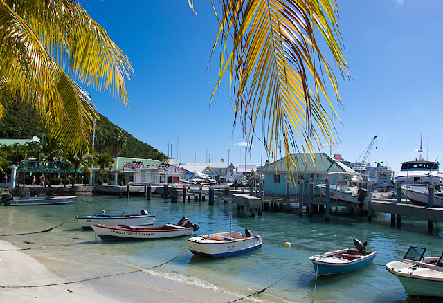
The Pier at Redcliffe Quay - St. John's, Antigua
Copyright Andy Richards 2025

IN 2015, we bought our retirement home in Palm Harbor, Florida (Tampa Bay area). By then we had focused our cruising pretty heavily on seeing the world in places like The Mediterranean and Europe. Reasoning that we now lived in a quasi-"Caribbean" place (it can get cool here in Florida, but never snows and most of the time is sunny and warm), we took a few-year hiatus from Caribbean Cruises.

Cargo Ship; St. George's, Grenada
Copyright Andy Richards 2014 - All Rights Reserved

THE COVID-19 pandemic hit the travel industry and patrons hard in 2020, and by the time we came up for air in late 2021, we were looking for any excuse to get on a cruise ship in just about any place again. We ultimately jumped back on a Princess ship (Regal Princess) in and around The English Channel, in late 2021. Then again in January, 2022 we were once again on the familiar old Celebrity Reflection, returning once again to the Caribbean (albeit this time the "Western Caribbean). We had missed the warm-weather cruising. Missed the relaxing days at sea and the always warm sunshine. We have cruise again in the Caribbean every year since.

in January, 2022 we were once again on the familiar old Celebrity Reflection, returning once again to the Caribbean (albeit this time the "Western Caribbean). We had missed the warm-weather cruising

THIS YEAR (2025) we boarded The Celebrity Beyond (the Celebrity fleet's 3rd of 5 in their "Edge Class" and a new ship for us), joined some friends we had met on a cruise in the Baltic in 2022. We had cruised with them on a very similar itinerary in 2023 in the Eastern Caribbean. As we always seem to do, we met some more new friends too (and will be joining them on a Caribbean Cruise again in 2027).

Incoming Cruise Ship; St. George's Bay, Grenada
Copyright Andy Richards 2025 - All Rights Reserved

IT SEEMS like the Caribbean Cruises get kind of "same old, same old," after a while. But we always find something new to do and learn something new about ports (even the ones we have visited multiple times). This year, our 11-day cruise stopped at St. Maarten (where we have ported multiple times), St. Lucia (we spent a day there in 2023), Grenada (once in 2014), Barbados (a day in 2023) and Antigua (again, a day in 2023). On our cruises in Europe and other parts of the world, we try hard to make the most of our shore time, booking an ambitious schedule of excursions. On the Caribbean cruises, we have developed a much more "laid back" style of travel. We booked just two formal events and let things fall where they did, on the rest of the ports.

Fuel Tanker - Castries, St. Lucia
Copyright Andy Richards 2025 - All Rights Reserved

OUR FIRST stop was St. Maarten, and it had actually been a few years since we had been there. The main line cruise ships all dock in the more accessible deep-water port of Phillipsburg, on the Dutch side of the island. As some readers may know, St. Maarten is divided north and south with the Dutch territory being roughly the southern half of the island, and the northern half: French territory (up there is it know as St. Martin). We have only ventured up to the French side on one of our four times there. Nothing against it. Just circumstances. Our first trip was our first time in the Caribbean, and it had been a very eventful year. We did not book much in the way of excursions. In St. Maarten, we walked around the main street of Phillipsburg, had lunch in a shady spot on a quiet beach in the city's marina, and generally kicked back. The second trip, we made up for it, taking a guided tour around the entire island and spending a couple hours in the main town in the French side: Marigot. The third trip was with a group of two other couples from Michigan and we elected to rent chairs on the beach and have a few beers. This year, we had no real plans other than to get off again and walk around. On the first day on board, we met our newest Candian friends: Sandi and Steve, who live just north of Niagara Falls in Port Erie, Ontario. They knew of a special cigar shop and liquor store and we agreed we would get off the ship together and walk around with a mission to find it. We did, but the rest is pretty much anti-climactic. Due to world conditions they had virtually no cigar inventory. I ended up buying a couple that were purported to be rolled in St. Maarten using cuban leaves (no tobacco is grown in St. Maarten). They weren't very good. I did get a nice deal on a couple bottles of very nice bourbon. It was a showery day and I didn't even bother with the camera that day.

In 2023, I started purposefully making photos of these "welcome" signs  (didn't get this one in 2023, but made it a point to do it this time)
Copyright Andy Richards 2025 - All Rights Reserved

ST. LUCIA was the next stop (so-called southern Caribbean cruises generally involve about a day and 1/2 to get down there, daily stops for 4-6 days, and a day and 1/2 to get back to Ft. Lauderdale. We had been there 2 years ago, with the same group and taken a very nice tour around the island, seeing some of the highlights like the rainforest, a very nice botanical garden, and from the distance: the island's famed landmark twin peaks of the Piton mountains. That group generally goes to a beach at most stops. We don't, so in those cases we fend for ourselves. But this day, none of us had "a plan," so we got off and walked around, staying mostly in the tourist area at the port.

"Birdseye View" of our Celebrity Beyond Cruise ship (From Ft. Frederick)
St. George's, Grenada
Copyright Andy Richards 2025 - All Rights Reserved

MY WIFE and I had booked an excursion for the following day in Grenada. True to form, our travel mates sought out a beach and enjoyed the tropical weather. To put things in perspective, they live near Buffalo, New York and had endured one of the hardest winters on record there. They were trying to soak up as much sun as they could to take back to (well, almost) the "North Pole" with them. In 2014, our only other stop in Grenada, my wife had a (thankfully minor) health emergency. We had arranged for a multi-passenger golf cart and driver to take us around the island and we had to back out at the last minute. More than 10 years later, we had a chance to get that back.

Grenada's seat of government, the Parliament Building, sits high up on a hill in St. Georges (but not the highest viewpoint), giving some great photographic views from the grounds
Copyright Andy Richards 2025 - All Rights Reserved

THE EXCURSION was pretty good and very interesting. We began the day with a stop at Grenada's Capital seat (Grenada is a parliamentary system, and they call it their "Parliament" building). With a population of just under 120,000, Grenada is part of the British West Indies federation. While King Charles is the titular "head of state," the country is primarily run and governed by the Parliament with the Prime Minister being the leader of the government. If I can say so, the Parliament is both austere and grandiose at the same time. We did not go inside but it appears from the glimpses we got that it is built for utility. I did find a few nice views from the grounds, however.

A view to the south, from the Parliament Grounds
Copyright Andy Richards 2025 - All Rights Reserved

TO THE south you can see houses in the hills, and what was apparently a stately mansion which appears to be in a state of disrepair today. Yet I still found it photogenic. To the west, there is a nice view of the St. George's (Carenage) inner harbor. We drove around the harbor at the end of our excursion, but did not stop. On my next stop in Grenada, I want to make my way to the harbor, and walk around. It was full of boats - mostly the working fishing fleet which did not seem to be out on that day - and surrounded by colorful buildings. It would be a fun "walk-around."

Carenage Harbor from the Parliament Grounds
St. George's, Grenada
Copyright Andy Richards 2025 - All Rights Reserved

OFF IN yet another direction was a view of a less urban flavor, looking at some of the rural housing and businesses on the island. As so often happens, it was the splash of color that drew the eye. Careful observers might note that the painted wall along the road sports Grenada's official colors and mimmicks the Flag of Grenada.

Rural Landscape as viewed from the Grenada Parliament
St. George's, Grenada
Copyright Andy Richards 2025 - All Rights Reserved

THERE ARE 3 (remaining) forts on Grenada: Ft. George, Ft. Frederick and Ft. Matthew. Two of them (George and Matthew) are under major reconstruction and cannot be visited. The last one is the smallest and there isn't a lot to see, but the views down and over the town of St. George's are amazing; and the history fascinating. The three forts are all on high points with commanding views. The largest, Ft. George, is on the other side of the inner harbor from the other two, between the Caribbean (St. George's Bay) and the Carenage Harbor. According to our guide at the fort, they are also all connected by underground tunnels. We could see Ft. George and its commanding postion in the center of the island facing the port of St. George's. Ft. Frederick is probably the smallest fort and although the buildings were mildly interesting to me, I mostly took advantage of the high viewpoint to make some photographs.

From high above the Parliament Building (from Ft. Frederick) yields a more dramatic and complete view of the building. I was hoping we would have an opportunity to see it from up above, and was pleasantly surprised.
Copyright Andy Richards 2025 - All Rights Reserved

AFTER THE fort, our driver took us to a beautiful park a ways south of the cruise port, with a large field overlooking the Caribbean. Known as "Quarantine Park," it is out on a point jutting out into St. George's Bay. Though the views were impressive, including a shot of our Celebrity Beyond Cruise Ship, it was a very windy day and our stay was rather short.
Celebrity Beyond docked at St. George's Cruise Port and viewed from Quarantine Point - approximately 2 miles away
Copyright "Andy Richards 2025 - All Rights Reserved
GRENADA IS known in the Caribbean as "The Spice Island," ("not to be confused with the historical "Spice Isles" of Indonesia) as numerous various spices are its primary export. Most of them are native to the island. Ironically, the one that isn't, nutmeg, was brought into Grenada in 1843, when a British ship left a small number of nutmeg trees on the island. Information is mixed, as are its sources, but our guide (and at least one internet sight found on Google agreed) told us Grenada is the second largest producer of nutmeg in the world; second only to Indonesia. Other sources differ with that ranking, but suffice it to say, they all agree that Grenada is a significant provider of the nutmeg consumed in the world. Other importan spices are turmeric, coco, mace and cardamon. During our stop, our guide gave us a quick demonstration of the fresh spices, even offering them up for taste, before delivering us back to our ship.

Quarantine Park - St. George's, Grenada
Copyright Andy Richards 2025 - All Rights Reserved

THE STORY behind Quarantine Point/Quarantine park is that in the 1892, the then governor of Grenada built an area (it is very small) out on this rather isolated point to isolate victims of smallpox, yellow fever, malaria and similar highly contagious and communicable diseases of the times. In modern days, the property has been converted into a public recreational space, hosting public events and cultural gatherings. Today, the park is flanked by several very high-end beach resorts.

St. George's, Grenada from the deck of our Celebrity Beyond Cruise Ship
Copyright Andy Richards 2025 - All Rights Reserved

JUST SOUTH of us lies the famous St. George's University. Our driver drove us through the impressive and attractive campus. Another thing I would like to do on another trip to Grenada is spend some time (camera in hand, of course) walking around the campus. Situated in perhaps the most affluent area of St. George's, the campus is relatively compact. The university opened in 1977 (chartered in 1976 by Grenada's parliament), as strictly a medical school. The brainchild of several U.S. residents, it was started as an alternative to U.S. students who weren't granted admission to any U.S. medical schools. By 1999, the university had added a liberal arts program, and degrees in veterinary medicine soon followed.

St. George's, Grenada from the deck of our Celebrity Beyond Cruise Ship
Copyright Andy Richards 2025 - All Rights Reserved

FOR ME what gives it its notoriety to the many of us who are not directly involved in the medical profession was its role in the only direct military action of the Reagan presidency. In 1979, there was a forced turnover of the long-entrenched, conservative prime minister, Eric Gairy (serving and instrumental in the charter and establishment of the university), by a Marxist regime, resulting in the ousting of Gairy and the establishment of Maurice Bishop as the new prime minister. For years of dissaray and infighting resulted in violence. In 1983, Bishop and several of his ministers were executed by an insurgent element in Bishop's own party. In a rather drastic approach, the newly controlled government instituted martial law, including a "shoot on sight" curfew. The U.S. was concerned about the 1,000 - odd U.S. citizens in Grenada, including over 100 students at the university. Encouraged by U.S. and British, U.S. troops conducted a surprise invasion of Grenada, presumably to rescue U.S. citizens. It was controversial. I'll leave it at that. But there is history there, and it was fascinating to see the university in person.

St. George's, Grenada from the deck of our Celebrity Beyond Cruise Ship
Copyright Andy Richards 2025 - All Rights Reserved

THAT ENDED our day and we returned to the ship. The sunlight of the late afternoon was setting over the city and from the viewpoint of our cruise ship deck, I made some nice photos of the city. Like so many cities all over the world, the landscape is often punctuated by church steeples. St. George's is no exception.

Sign in the Caribbean - giving off that "Caribbean Vibe," Mon
Copyright Andy Richards 2025 - All Rights Reserved

THE FOLLOWING day, our stop was Barbados. The only other time I was there was in 2023, with the same group. They went to the beach. I demurred, planning to go ashore and explore. When there is no shuttle running from the ship to the port terminal, it is quite a long walk around the jetty to the terminal. The terminal is similar to most modern cruise terminal stops in the Caribbean. Tourist trap. On steriods. Intending to walk out an explore, to me everything looked really sketchy. One of those fimes I should have done my homework. But I hadn't, and not feeling particularly adventurous, I walked around the terminal for a few minutes, bought a T-shirt, and returned to the ship. My bad. This time I did do some homework. I learned that there is a nice beach/boardwalk just outside the port, and it is a short distance to the center of town, where there are some impressive colonial structures. I will check them out. Next time.

"Tall Ship" style cruise ship - St. John's, Antigua
Copyright, Andy Richards 2025 - All Rights Reserved

THIS TIME, I had another mission. As a younger person, I played in the pit orchestra for my home city's players performance of the humorous historical musical: 1776. I remember lines from a particularly dark song about slavery that ended with the phrase: "Barbados and rum." I have always remember the connection and during my homework session, discovered Mt. Gay Rum distillery (the oldest in the Caribbean). I had a hankering for a tasting, and my wife and I made an appointment. I must have liked it because I brought 2 liters home with me. 😊

Redcliffe Quay; St. John's, Antigua
Copyright Andy Richards 2025 -All Rights Reserved

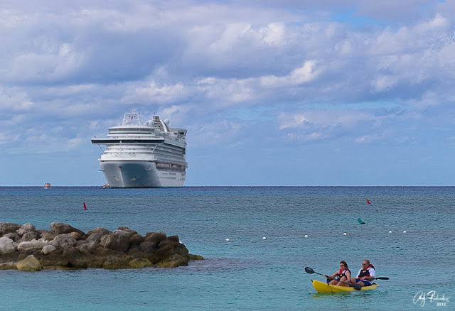
OUR FINAL port stop was St. John's Antigua. Again, my sole other visit there was in 2023. On that day our whole group got off and hired a driver to take us all around the island. It was a long, but very fun day. There is an awful lot going on on this island. We had such an in-depth excursion that when we returned to the port we were ready to get back on board, get cleaned up, and relax over pre-dinner cocktails. We didn't explore the immediate port area. The main cruise port today in St. John's is "Heritage Quay." It is large enough to dock multiple ships and on this trip we shared the dock with one of Princess' newest and best: The Enchanted Princess. It is a beautiful ship and given the opportunity I couldn't resist photographing her, as well as our Beyond side-by-side.

Redcliffe Quay; St. John's, Antigua
Copyright Andy Richards 2025 -All Rights Reserved

PRIOR TO the cruise, my pre-cruise research involved searching for things to do in St. John's. For the most part, it seemed like we had done or seen most of it. There was one area, though, right under our "proverbial nose," that we had missed. The legacy port immediately adjacent to Heritage Quay is Redclifee Quay. It is still there and still being used by some smaller cruise ships and some specialty cruise ships (like the "tall ship" cruiser docked on the Redcliffe Quay pier). As such the older buildings of a retro-cruise port remain. They continue to operate as shops and restaurants and are beautifully maintained in their colorful painted clapboard form. I got off the ship alone this time, with a short mission: to photograph as much of Redcliffe Quay as there was to shoot. Turns out is is pretty small. Still I had some fun and made a few pictures.

Redcliffe Quay; St. John's, Antigua
Copyright Andy Richards 2025 -All Rights Reserved

THE NEXT two full days were spent "at sea," returning to Fort Lauderdale. Ironically, the entire first part of the cruise, including the downward sail, and every day except for Antigua, were very windy. Indeed this is the windiest Caribbean Cruise we have been on. Then from Antigua on, things turned calm and it finally felt like the Caribbean we remembered. Little wind, calm seas, and lots and lots of sunshine. So those last sea days were delightful. Just enough to get us back again. On board, we booked February Caribbean Cruises for 2026 and 2027. Both will be on "new" ships for us (Ascent in 2026 and the older solstice class Eclipse in 2027). 2027 will bring 3 new islands for us - the so-called "ABC" Islands of Aruba, Bonaire and Curaco, in addition to 3 familiar eastern Caribbean Islands. Lots to look forward to - intermixed with our other cruises.

The Enchanted Princess - St. John's, Antigua
Copyright Andy Richards 2025 - Al Rights Reserved

OUR NEXT cruise will be in August/September, on the Celebrity Apex out of Southampton, England to the Norwegian Fjords. Stay tuned!

Celebrity Beyond and Princess Enchanted Princess - St. John's Antigua
Copyright Andy Richards 2025 - All Rights Reserved