 |
| "Lateral Navigation" Buoys |
LIKEWISE, THERE are rules for navigating the waters of the world. But there are some distinct and unique differences. First, the oceans do not present nearly as clearly defined borders. You generally know when you are driving on a road in a particular country, and when you reach the borders. While there are somewhat defined "territorial" borders in the world's oceans, they are certainly not nearly as clear cut. Because the oceans are used for shipping and passenger transport all over the world by many different nations, the traffic is multi-national, which can lead to confusion by "users" of the waterways. On a nation's roadways, we can generally count on the majority of the occupants being residents of the country (and therefore, familiar with its rules).
 |
| Lateral Channel Marker Red Buoy |
BECAUSE OF these differences, the rules are perhaps closer to "universal" on the world's waterways. But they are still not completely uniform. I grew up in Michigan (not coincidentally nicknamed "The Great Lakes State"), which is essentially a peninsula in one the country's "freshwater oceans." Surrounded on 3 sides by what is really a geographically single ocean, the 3 separate divisions are separately named: Lake Michigan to the west, Lake Huron to the east, and Lake Superior to the north. For those of us who have lived in Michigan, Minnesota, Wisconsin, Illinois, Ohio and Canada, it is familiar territory for big water shipping and pleasure cruising alike. There are more than 10,000 inland lakes in Michigan also (the 4th most behind Alaska, Wisconsin, and Minnesota). Grandparents on both sides of my family owned summer cottages on two of them. We lived on Lake Michigan. I was in and out of small boats from the time I was 10 or so. I have piloted small power craft and sailboats on both inland lakes and The Great Lakes and have cruised on The Great Lakes in the U.S. and Canada. All this is to say I felt like I knew a little something about boating - and the so-called "rules of the road." And ever the self-absorbed "American," I just assumed that the world followed our rules. 😳Well I was wrong (first time ever, right? )😑
I OFTEN comment here that I learn something (things??) on nearly every cruise. When we were in Warnemunde, Germany on the Celebrity Apex in the Baltic back in 2022, I watched this passenger ferry returning to port with some interest. As a photographer, I was interested in the symmetry of the boat splitting the lines of navigational buoys. I thought it made a nice image. But perhaps what struck me more strongly was my "what's wrong with this picture?" sense. From the time of my youth, I had learned about the universal red and green navigational aids to demark channels. Most know that the safest route is to stay between them. But seasoned sailors also know that there is a hierarchy. When leaving the port, the red makers or buoys are to your right (starboard in nautical terms), and the green to your left (port - meaning left and not to be confused with "the port"). Returning to the port, this scheme is reversed. To ingrain this, we were all taught a little ditty: "red, right, returning." Easy, right?
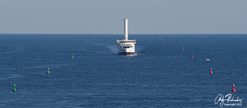 |
| Passenger Ferry returning to port in Warnemunde, Germany Copyright Andy Richards 2022 - All Rights Reserved |
WELL. NOT so fast. What's wrong with this picture? This boat is (take my word for it as I was standing on the cruise ship deck in the port) definitely "returning." But why are all those green buoys on the right? What the . . .? Did I have that all wrong? Was it really "green, right, returning?" That just doesn't have the ring to it, does it?
THE HISTORY here is interesting. Prior to the 1970's, much like the automobile rules of the road, most different countries operated by their own channel marking system (sometimes referred to as buoyage, by nautical terminology). In fact, there were at least 30 of them. Given the factors above that make ocean going traffic unique, it seems like that was a recipe for disaster. It took a series of disasters in the English Channel in 1971 to bring this issue to the forefront. On a January day a collision occurred in the channel between a Peruvian Freighter and a Panamanian Oil Tanker, sinking the tanker and killing 8 sailors. The British authorities immediately placed lights to warn other ships off of the shallow wreck. In spite of that, the very next day a West German Freighter struck the wreck and sank, killing 21 more sailors. The British authorities placed a light ship and more markers. Even then, a month later a Greek Cargo ship struck the wreck and sank, resulting in 22 more lost lives. These incidents are believed to have been the principal inspiration for an organization known as the International Association of Marine Aids to Navigation (IALA) to create a uniform navigational aid standard for buoy and channel marking systems. Ratified by member nations in 1982, the system consolidated the 30 prior standards into the two separate, but similar systems in place today.
 |
| IALA Region A - Buoy/Marker system |
THE NEW standard created two separate regions: A and B. Region A consists of Europe, Australia, New Zealand, parts of Africa and most of Asia. When entering a harbor in this region, marks to port are red and marks to starboard are green.
 |
| IALA Region B - Buoy/Marker system |
NORTH AMERICA, Central America, South America, the Philippines, Japan and Korea are, conversely, in Region B. When entering a harbor in this region, marks to port are green and marks to starboard are red (red, right, return).
WHY TWO separate systems? The answer to this is not crystal-clear, but it appears that some member nations - notably the United States of America - had so much already invested in its maritime marker system that it would not have been economically, nor practically, feasible to change them. This system extended well down into the South American Continent, and the Caribbean. They (mainly red/green, port/starboard system of markers) were opposite of what "the rest of the world" considered standard. The result was two systems. A compromise for sure (but nothing really different than how we treat weights and measures throughout the world).
THERE ARE a couple other important points of standardization, which apply in both regions. Whether red or green, all channel markers to the left (port) when returning to port shall be flat topped or square (buoys are known as "cans") and odd-numbered, and markers to the starboard shall be either conical, triangular, or pointed topped (buoys are known as "nuns") and are even numbered. Numbers increase as you get farther away from port. Regardless of the region, markers may be only red or green.
 |
| Red and Green Channel Marker Buoys ready to be launched |


No comments:
Post a Comment
I WOULD LOVE TO READ YOUR COMMENTS: